Valais W - Alpes Pennines W

21 Touren in Valais W - Alpes Pennines W. Finden Sie Ihre nächste Route auf Isomaps — Topokarten, GPS und Höhenprofil.
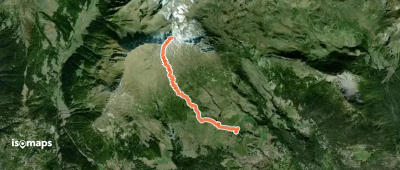
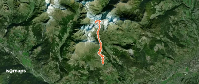
Lac Mort supérieur de Fallère - Circuit des lacs

Mont Fallère, Italie

13,87 km +1 310 m 4h 10min

Mittel
Mont Rouge de Vertosan - Versant SW épaule 2754 m

Monte Rosso, Italie

16,32 km +1 050 m 4h 25min

Mittel
Grand Créton N - Par le vallon de Planaval

Gressan, Italie

14,31 km +1 315 m 4h 10min

Mittel
Mont de Vertosan - Sommet S - Par le vallon de Verrogne

Monte Rosso, Italie

13,00 km +1 290 m 4h 0min

Mittel
Route camptocamp 671407

Valtournenche, Italie

11,17 km +1 296 m 4h 15min

Mittel
Pointe Oilletta - De Vens

Pointe Aouillette, Italie

8,85 km +884 m 2h 10min

Einfach
Pointe de Dziule - Boucle par le vallon de Vertosan

Testa Serena, Italie

21,00 km +1 100 m 4h 55min

Mittel
Col d'Ars - versant E

Mont Fallère, Italie

14,86 km +1 300 m 3h 45min

Einfach
Refuge Bertone - de Courmayeur

Courmayeur, Italie

4,43 km +631 m 2h 0min

Mittel
Combe des Lacs - Lac Mort, lac Long, lac de la Tête, lac du Mont Rouge

Pointe de Boette, Italie

10,61 km +1 080 m 2h 40min

Mittel
Pain de Sucre du Fourchon - Arête SE - Zucchero

Tête de Fonteinte, Italie

4,95 km +600 m 1h 35min

Mittel
Court de Bard - Circuit par l'arbre monumental

Derby-Villaret, Italie

9,74 km +650 m 2h 35min

Mittel
Mont Fallère - par le Vallon de Clusellaz

Mont Fallère, Italie

15,34 km +1 450 m 4h 45min

Mittel
Pointe de Chaligne - Circuit pointe de Chaligne > Pointe de Metz

Pointe Chaligne, Italie

22,60 km +1 393 m 5h 50min

Mittel
Refuge Frassati - Par le vallon des Merdeux

Testa di Crevacol, Italie

6,35 km +0 m 1h 35min

Mittel
Bec Etresenta - Couloir W "Mythe de la caverne"

Aosta, Italie

8,91 km +1 400 m 1h 45min

Sehr schwer
Les Ors - A travers champs

Cheverel, Italie

15,47 km +640 m 3h 10min

Mittel
Route camptocamp 789610

Aosta, Italie

34,05 km +1 750 m 7h 25min

Mittel

Bereit für Ihren nächsten Ausflug?

Testen Sie Iso Maps 7 Tage kostenlos. Verfügbar für iOS und Android.

Für iOS herunterladen Für Android herunterladen APK (ohne Google)