Valais E - Alpes Pennines E

17 Touren in Valais E - Alpes Pennines E. Finden Sie Ihre nächste Route auf Isomaps — Topokarten, GPS und Höhenprofil.

Route camptocamp 422261

Stolemberg, Italy

11,34 km +771 m 2h 50min

Schwer
Motte de Plété Centrale - Par le versant NW

Breuil-Cervinia, Italy

6,55 km +750 m 1h 40min

Mittel
Route camptocamp 206424

Pizzo Tignaga, Italy

14,52 km +1 700 m 5h 10min

Mittel
Route camptocamp 57658

Cuneaz, Italy

6,83 km +889 m 1h 20min

Mittel
Petit Tournalin, normale

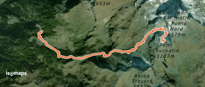
Valtournenche, Italy

5,44 km +1 162 m 30min

Einfach
Route camptocamp 671441

Grand Tournalin, Italy

16,18 km +1 219 m 4h 50min

Mittel
Route camptocamp 49889

Gattascosa, Bocchetta, Italy

13,12 km +1 344 m 3h 35min

Einfach
Route camptocamp 196803

Monte Prevor, Italy

6,01 km +1 151 m 2h 55min

Einfach
Route camptocamp 1312800

Viera, Italy

1,57 km +434 m 20min

Mittel
Route camptocamp 605050

Punta di Trivera, Italy

8,38 km +1 050 m 3h 15min

Mittel
Route camptocamp 892990

Favaro, Italy

2,01 km +435 m 25min

Mittel
Pointe Falinère - Par Cheneil

Cheneil, Italy

5,04 km +739 m 1h 15min

Mittel
Route camptocamp 157039

Rumianca, Italy

9,53 km +1 912 m 5h 15min

Mittel
Lac de Brusson - Ru d'Arlaz

Challand-Saint-Anselme, Italy

11,67 km +400 m 2h 20min

Mittel
Route camptocamp 276316

Macugnaga, Italy

10,93 km +1 108 m 4h 15min

Mittel

Bereit für Ihren nächsten Ausflug?

Testen Sie Iso Maps 7 Tage kostenlos. Verfügbar für iOS und Android.

Für iOS herunterladen Für Android herunterladen APK (ohne Google)