Nordrhein-Westfalen

6,248 itinéraires dans Nordrhein-Westfalen. Trouvez votre prochain parcours sur Isomaps — cartes topo, GPS et profil altimétrique.
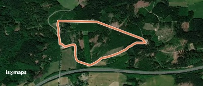
Wellin Rundweg T

Rärin, Allemagne

3,00 km +136 m 45min

Très facile
Ahden A5
Ahden A5

Ahden, Allemagne

3,03 km +124 m 45min

Très facile
Alter Klosterweg
Alter Klosterweg

Marschallshagen, Allemagne

5,29 km +191 m 1h 15min

Très facile
Bockstall Rundweg A4

Niedereimer, Allemagne

6,41 km +234 m 1h 30min

Très facile
Wulmeringhausen Rundweg W1

Assinghausen, Allemagne

4,77 km +114 m 1h 20min

Très facile
Neuenhof Rundweg A1
Neuenhof Rundweg A1

Radevormwald, Allemagne

3,50 km +124 m 50min

Très facile
Hochwildpark Rheinland - Route

Mechernich, Allemagne

9,24 km +264 m 2h 15min

Facile
Reiste Rundwanderweg Re2

Reiste, Allemagne

8,52 km +347 m 2h 20min

Facile
Bleiwäsche B1
Bleiwäsche B1

Bleiwäsche, Allemagne

5,98 km +152 m 1h 25min

Très facile
[U] Rundweg weißes U Wanderparkplatz Asselborner Mühle
[U] Rundweg weißes U Wanderparkplatz Asselborner Mühle

Büchel, Allemagne

4,85 km +199 m 1h 20min

Très facile
Meinkenbracht Rundweg A2

Meinkenbracht, Allemagne

4,38 km +192 m 1h 15min

Très facile
Viadukt-Wanderweg
Viadukt-Wanderweg

Altenbeken, Allemagne

28,57 km +963 m 7h 25min

Difficile
(G) Rund um Gevelsberg

Gevelsberg, Allemagne

14,21 km +559 m 3h 50min

Modéré
Wolfsegge Rundweg A3

Schwelm, Allemagne

7,39 km +343 m 2h 10min

Facile
Rundweg Balken Altwindeck

Schladern, Allemagne

3,82 km +166 m 1h 10min

Très facile
Hespert-Silberkuhle Rundweg A1

Tillkausen, Allemagne

2,64 km +98 m 35min

Très facile
Zugangsweg Hermannshöhen - Altenbeken

Altenbeken, Allemagne

3,77 km +202 m 50min

Très facile
[W5] Werdohl Rundweg

Dornwerth, Allemagne

15,90 km +859 m 5h 35min

Difficile
Wulmeringhausen Rundweg W2

Overlackersberg, Allemagne

5,70 km +300 m 1h 55min

Facile
Waldroute - Zubringer Völlinghausen

Neuhaus, Allemagne

1,97 km +119 m 30min

Très facile

Prêt pour votre prochaine sortie ?

Essayez Iso Maps gratuitement pendant 7 jours. Disponible sur iOS et Android.

Télécharger sur iOS Télécharger sur Android APK (sans Google)