Sud Tyrol

6 itinéraires dans Sud Tyrol. Trouvez votre prochain parcours sur Isomaps — cartes topo, GPS et profil altimétrique.

Rote Wand depuis Antholz (Italie)

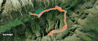
Zona Turistica Anterselva Alta, Italy

19,26 km +1 200 m 5h 5min

Très facile
Botzer depuis le Sud

Monte Rombo, Italy

8,14 km +1 550 m 2h 0min

Facile
Alpenspitz en boucle

Innerwalten, Italy

9,67 km +1 060 m 3h 15min

Facile
Hohe Kreuzspitze 
Hohe Kreuzspitze 

Corvara, Italy

12,88 km +1 100 m 3h 50min

Facile
Hinterer Kitzkogel depuis l'Italie 

Monte Rombo, Italy

5,64 km +1 300 m 3h 5min

Modéré
Rotlahner, Par Kasermähder Alm

Santa Maddalena, Italy

7,86 km +1 250 m 3h 40min

Facile

Prêt pour votre prochaine sortie ?

Essayez Iso Maps gratuitement pendant 7 jours. Disponible sur iOS et Android.

Télécharger sur iOS Télécharger sur Android APK (sans Google)