Alpes du Nord

1,077 itinéraires dans Alpes du Nord. Trouvez votre prochain parcours sur Isomaps — cartes topo, GPS et profil altimétrique.
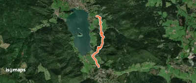
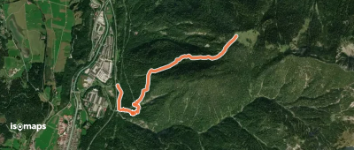
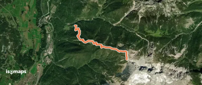
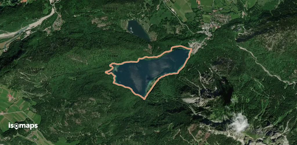
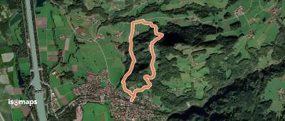
Die Alpenüberquerung - Etappe 2

Wildbad Kreuth, Allemagne

9,75 km +1 016 m 4h 35min

Difficile
AV Weg 417
AV Weg 417

Hintergern, Allemagne

13,36 km +2 039 m 6h 30min

Très difficile
Blomberg Zwiesel
Blomberg Zwiesel

Sauersberger Alpe, Allemagne

9,19 km +743 m 3h 25min

Facile
Wanderweg 653 - Brünnstein

Schmiedalpe, Allemagne

7,44 km +752 m 3h 20min

Modéré
AV Weg 423
AV Weg 423

Kärlingerhaus am Funtensee, Allemagne

2,04 km +281 m 50min

Facile
Wanderweg 532
Wanderweg 532

Waakirchen, Allemagne

9,86 km +169 m 2h 0min

Facile
Wanderweg 12 - Bad Feilnbach

Brannenburg, Allemagne

5,83 km +365 m 2h 0min

Facile
Via Alpina Red R45
Via Alpina Red R45

Nordöstliche Dreitorspitz, Allemagne

11,39 km +652 m 6h 10min

Difficile
Wanderweg 251
Wanderweg 251

Griesen, Allemagne

5,42 km +1 334 m 2h 55min

Difficile
Premiumwanderweg Nagelfluhschleife Alpenfreiheit

Fluh Alpe, Allemagne

13,79 km +718 m 4h 55min

Difficile
Wanderweg 70
Wanderweg 70

Ruhpolding, Allemagne

1,95 km +105 m 35min

Très facile
Leiblweg
Leiblweg

Bad Feilnbach, Allemagne

3,68 km +245 m 1h 30min

Très facile
Wanderweg 70 (Rund um den Toten Mann)

Götschenkopf, Allemagne

12,31 km +529 m 3h 30min

Modéré
Terrainkurweg "Wilhelm-Leibl"

Bad Feilnbach, Allemagne

6,40 km +266 m 1h 55min

Facile
Wanderweg H 1 - Isarwinkel

Wackersberg, Allemagne

3,20 km +110 m 45min

Très facile
Wanderweg W 9 - Isarwinkel

Wackersberg, Allemagne

2,97 km +107 m 45min

Très facile
Nord Süd Trail, Abschnitt Weiler im Allgäu - Ofterschwang

Weiler-Simmerberg, Allemagne

87,04 km +5 872 m 32h 25min

Très difficile
Barmstein-Runde
Barmstein-Runde

Marktschellenberg, Allemagne

6,67 km +489 m 2h 35min

Facile
OSM Route 19967896
OSM Route 19967896

Lenggries, Allemagne

2,36 km +68 m 35min

Très facile
Wanderweg 480 - Isarwinkel

Tanneralpe, Allemagne

1,34 km +351 m 50min

Facile

Prêt pour votre prochaine sortie ?

Essayez Iso Maps gratuitement pendant 7 jours. Disponible sur iOS et Android.

Télécharger sur iOS Télécharger sur Android APK (sans Google)