Bayern

4,193 itinéraires dans Bayern. Trouvez votre prochain parcours sur Isomaps — cartes topo, GPS et profil altimétrique.

Pferdehofweg
Pferdehofweg

Eichelburg, Allemagne

5,03 km +50 m 1h 0min

Très facile
Wanderweg Roter Tropfen

Ebrach, Allemagne

17,10 km +337 m 3h 55min

Modéré
Naturerlebnispfad Rußweiher

Holzmühle, Allemagne

5,95 km +24 m 1h 10min

Très facile
Lehrpfad Käfer und Co Breitengüßbach

Breitengüßbach, Allemagne

2,75 km +27 m 35min

Très facile
Wanderweg 10 - Bad Endorf

Moosen, Allemagne

8,95 km +117 m 1h 50min

Facile
Wildhügelweg
Wildhügelweg

Neuensee, Allemagne

8,42 km +145 m 1h 50min

Facile
Rundweg Prüssberg P1

Michelau, Allemagne

3,25 km +83 m 45min

Très facile
Nordic Walking Ising

Arlaching, Allemagne

8,75 km +102 m 1h 45min

Facile
Neuendettelsauer Wanderweg Nr. 31

Watzendorf, Allemagne

9,22 km +145 m 1h 55min

Facile
Lauschtour
Lauschtour

Roggenburg, Allemagne

5,17 km +104 m 1h 10min

Très facile
OSM Route 6805355
OSM Route 6805355

Hübschenried, Allemagne

13,18 km +95 m 2h 35min

Facile
Neunkirchen am Sand Rundwanderweg Rot 6

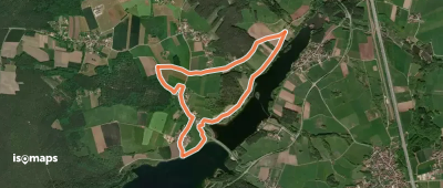
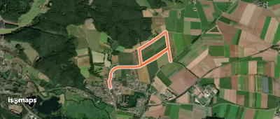
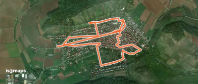
Neunkirchen am Sand, Allemagne

10,66 km +555 m 2h 40min

Facile
Waldlehrpfad Bürgstadt, PP Stutz

Bürgstadt, Allemagne

2,27 km +108 m 35min

Très facile
Ellertal Nord - Stammberg - Rundweg

Litzendorf, Allemagne

13,96 km +428 m 3h 25min

Facile
Panoramaweg
Panoramaweg

Halfing, Allemagne

10,76 km +182 m 2h 15min

Facile
Wanderroute Via Nova

Neustadt an der Donau, Allemagne

876,09 km +20 288 m 195h 30min

Très difficile
Verbindungsweg Tröstau - Schmierofenhütte

Tröstau, Allemagne

5,57 km +192 m 1h 15min

Très facile
Weiße Marter
Weiße Marter

Etzenricht, Allemagne

2,80 km +39 m 35min

Très facile
Bildstockweg Greußenheim 1

Greußenheim, Allemagne

3,47 km +79 m 45min

Très facile
Rundwanderweg Bärnreuth

Bad Berneck im Fichtelgebirge, Allemagne

4,55 km +119 m 1h 0min

Très facile

Prêt pour votre prochaine sortie ?

Essayez Iso Maps gratuitement pendant 7 jours. Disponible sur iOS et Android.

Télécharger sur iOS Télécharger sur Android APK (sans Google)