Unstaffed hut · 2 920 m · Ronco Canavese
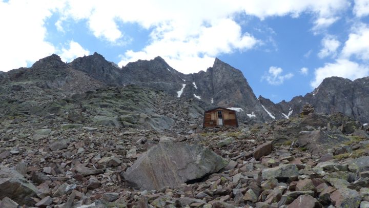
Unmanned bivouac located in the Valle di Valeille, at the foot of the eastern ridge of the Torre di Sant Andrea. It overlooks the Valeille glacier and is managed by a public authority.
Loading the forecast…
Bivouac located at the bottom of the Valle di Valeille, at the foot of the eastern ridge of the Torre di Sant Andrea, overlooking the Valeille glacier. From Lillaz (Cogne valley): Climb southwards along the long Valle di Valeille following path N°15. The path follows the left bank of the stream, crossing two scree tongues that cut across the route, the first of which is rather awkward due to large blocks (always stay level to avoid losing the path if the markings are missed ...). After reaching the height of the waterfall descending from the glacier di Sengie (right bank), you will cross an area covered with moraine debris somewhat overgrown with vegetation; it is easy to lose sight of the markings, in any case you must head towards the foot of the grassy moraine, always on the left bank (the path reaches it via a few switchbacks on the eastern side). Climb this long moraine entirely; you will then come across another moraine oriented NW-SE, which you climb on the right (do not miss the markings leading in that direction). The path climbs this steep moraine; above it you reach a flat area, then cross a small step to arrive at the level of the glacier, which you do not walk on; turn right to reach the bivouac via a wide ridge.
When climbing the moraines, you will notice a large cairn on the almost flat ridge that blocks the horizon to the south; the bivouac is just behind it. Indoor equipment: - 1 picnic table with 2 benches - 2 sleeping platforms with mattresses and blankets Water: The only water not too far away will be meltwater from the glacier, so if you want "better quality" water, you will need to fill up much lower down ...
No source says whether this hut is open. Missing information is not a guarantee.
This page brings together several open sources. The licences below apply to their respective content.
Try Isomaps free for 7 days. Available on iOS and Android.


