Unstaffed hut · 2 290 m · la Guingueta d'Àneu
Non-guarded refuge located in the Pallars Sobirà, managed by the municipality of la Guingueta d'Àneu.
Loading the forecast…
From the [->4918]: Climb up the Estany de la Gola along its right bank, then reach Coll Curios, turn east towards Col de Calberante, cross the pass and descend to the refuge while passing by all the Gallina Lakes. From Alos d'Isil: Follow the road/track up to Bordes de Pina, then turn full east to climb to Coll de la Cornella (steep on both sides at the end), then Coll Curios, then follow the same route as above. From the [->5361]: Cross Coll de Certascan, admiring the immense Certascan Lake along the way, you can climb Pic de Certascan via its southern ridge and return, then descend to the village of Noarre. From Noarre, take the path to Port de Tavascan, abandon it for a left-hand trail leading to Pleta Palomera, then head west to the valley floor at the foot of Mont-Rouch. A short climb to the left leads to Estany de Llavera (spring southwest of the pond), then follow the outflow of Estany Inferior de la Gallina to reach the refuge. From the [->5360]: Climb to Bordes de Quanca, then take the track (very degraded, accessible by 4WD) up to the trailhead leading to Pleta Palomera, then follow the same route as above.
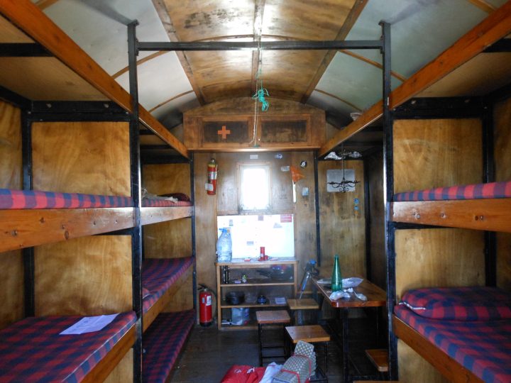
Refuge always open: - Excellent isolation - Remarkable condition, may it last ... - The refuge is said to accommodate 18 people, with 9 wide bunks; using the "head-to-toe" method allows fitting in ... (for smaller people). - A local shepherd sometimes occupies one bunk. Equipment: - Table - Benches + stools - First aid kit - Broom Water: - Lake water ... - To find fresh water, descend the outflow of the Estany next to the refuge down to Estany de Llavera, then head southwest towards the rocky barrier. A black/mossy section a few meters high provides easy access to clear water flowing from the rock.
No source says whether this hut is open. Missing information is not a guarantee.
This page brings together several open sources. The licences below apply to their respective content.
Try Isomaps free for 7 days. Available on iOS and Android.


